BIG EARTHQUAKE AT FORT OSAGE - Yes, It Happened... Kind Of

An 1877 woodcut imagined the panic and destruction caused by the New Madrid earthquakes of 1811 and 1812. (Public domain)
On Friday, March 15, 2024, residents of several communities in Platte County, Missouri, just northwest of Jackson County felt - in a most subtle way - the earth move beneath their feet.
They felt compelled to report the experience to the U.S. Geological Survey. Accordingly, the agency soon confirmed an approximately 3.5 magnitude earthquake had been recorded at a shallow depth of about six miles below the surface just northeast of Kansas City International Airport.
The quake, according to the Kansas City Star, had struck at approximately 1:45 p.m. Residents reported light shaking, while airport workers described a slight tremor. KCI representatives soon reported on social media that no damage had been discovered.
Meanwhile, if any Jackson County residents had felt anything, they didn’t notify the authorities.
So - it was no big deal.
That hadn’t been the case more than two centuries before at Fort Osage, some 27 miles northeast of the Truman Sports Complex. What happened at the recently constructed federal outpost not long after midnight was sufficiently unnerving that details of the event made news as far east as Philadelphia, with witnesses struggling to explain it.
This month’s E-Journal, in slightly different form, first appeared on FlatlandKC, (flatlandkc.org) the nonprofit newsroom operated by Kansas City PBS. The Jackson County Historical Society appreciates the permission to reprint this article.
By Brian Burnes
On December 16, 1811, a U.S. Army officer stationed in the soon-to-be-established Missouri Territory woke just after 2 a.m. reacting to what he described as a “great agitation.”
Several of the officer’s guards, he soon wrote to a friend, “could scarcely keep their feet” during the shaking, which lasted about eight minutes.
Several soldiers reported the violent trembling had been accompanied by “a noise something like that of distant thunder” and those on duty outside reported trees shedding all of their dead branches.
Subsequent inspections revealed damaged chimneys and loose plaster in several surrounding buildings.
“From the best observation we could make,” the officer wrote, the “different shocks came from the south, and I can account for the dreadful phenomenon no other way than premising an eruption of the earth to have taken place somewhere on the southern continent of America.”
Close - but not quite.
A far more horrific phenomenon had occurred in the southeast corner of what, 10 years later, would be declared the new state of Missouri.
There the trees had not merely shed branches but had tilted completely over while great fissures opened in the earth. Noxious clouds erupted from the ground while banks along the Mississippi River collapsed into the water, itself turbulent and angry, rocking flatboats back and forth.
All of it was accompanied by the screams of residents and wildlife. Even the current of the Mississippi, according to one New Madrid eyewitness “was retrogade (sic) for a few minutes” or, in more familiar language, ran backwards.
Also destroyed: much of the 1,000-member community of New Madrid, today located in what scientists today call the New Madrid Seismic Zone, a district which includes portions of Missouri, Arkansas, Tennessee, Kentucky and Illinois.
Today that is considered the most seismic area of the United States east of the Rocky Mountains.
The December earthquake was the first of three such events - the others occurring the following January and February - all later assigned a magnitude not previously not experienced since the first year of the French and Indian War.
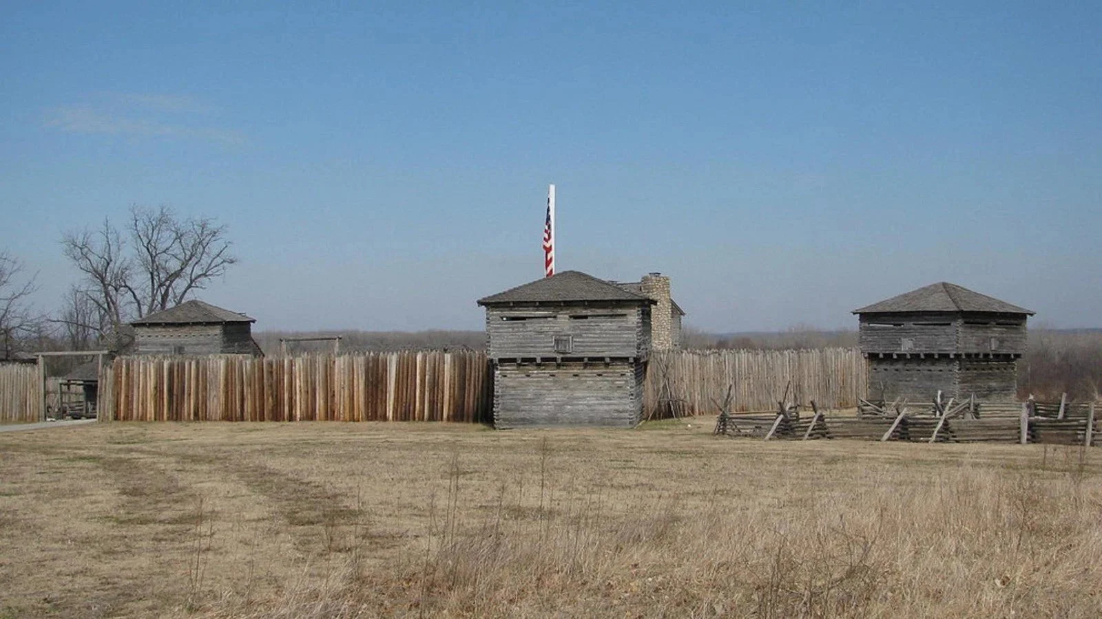
The reconstructed Fort Osage, a National Historic Landmark, is operated by the Jackson County Parks + Rec department, in northeastern Jackson County. (Jackson County Parks + Rec)
The rattled Army officer who described the shaking in December had not, however, been on duty down in New Madrid.
He had been stationed some 320 miles to the northwest at Fort Osage, the military garrison built three years before about 30 miles downriver from the confluence of the Missouri and Kansas rivers.
That was where fur trappers and others then were building the frontier outpost that would, in 1850, be incorporated as Kansas City.
Dropping, covering, holding on
Today the letter written by the Fort Osage officer represents the western-most eyewitness account maintained in the New Madrid Compendium (memphis.edu/ceri/compendium/), an online archive of more than 600 written references to the New Madrid earthquakes of 1811 and 1812 maintained by the University of Memphis.
The letter itself can be accessed in the compendium’s Far-Field Reports Database, which has collected published New Madrid earthquake accounts from more than 100 newspapers across the country, covering December 1811 through December of the following year.

An edition of the Aurora and General Advertiser in Philadelphia, PA included excerpts of a letter written a U.S. Army officer at Fort Osage, detailing the damage caused by the first New Madrid earthquake earlier that month. (Center for Earthquake Research and Information, University of Memphis)
The December 31, 1811 letter, apparently sent by the officer to a friend back east, soon appeared in an edition of the Philadelphia Aurora and General Advertiser.
Its editors must have found it newsworthy.
“The earthquakes were just so unprecedented,” said Kent Moran, a research associate with the university’s Center for Earthquake Research and Information.
“We did not have any such seismic events of this scale since 1755 in New England. So people felt compelled to write down their experiences.”
Today these accounts, although more than 200 years old, still inform the contemporary scientists who monitor and study earthquakes and the danger they represent, as well as emergency management officials trained to respond to them. The 19th century testimonies detail just what happened where, and when, and just how bad it was, Moran said.
This year - on Thursday, October 16 - Missouri will be among 14 states participating in the Great Central U.S. ShakeOut, a coordinated earthquake exercise.
At 10:16 a.m. participants will engage in a one-minute “Drop, Cover and Hold On” drill, which includes falling to the floor, finding cover underneath any available table or desk, and holding on.
“Its a one-minute exercise that everyone can do at the same time,” said Jeff Briggs, earthquake program manager for the Missouri State Emergency Management Agency (SEMA).
As of mid-July, Jackson County schools registered to participate in this year’s exercise include Indian Creek Elementary School in Kansas City’s Center School District, John W. Luff and Christian Ott elementary schools in the Independence School District, and the Oak Grove Primary School and the Charlene Roscher Early Childhood Center in the Oak Grove R-VI School District.
Last year a total of 448,879 Missouri residents participated, Briggs said.
That number, appropriately enough, included students attending schools in the Fort Osage School District, whose boundaries include the small Missouri River community of Sibley, home of the reconstructed Fort Osage, today a National Historic Landmark maintained by the Jackson County Parks + Rec department.
District schools conduct safety drills throughout the school year to ensure students and staff know what to do in the event of an emergency, said Stephanie Smith, Fort Osage School District public relations director.
Those emergencies could include fires, tornadoes and other unexpected events, such as earthquakes, she added.
“These practice drills are a key part of our commitment to keeping everyone in our schools safe and prepared,” Smith said. “When students are familiar with the procedures, they can respond more confidently and calmly if a real emergencies ever occurs.”
Preparing for the worst
In July of 2024, a 500-member task force, coordinated by the City of St. Louis and the Missouri National Guard, organized a three-day exercise to drill first responders during an imagined earthquake emergency.
Authorities closed downtown streets near and around Busch Stadium.
Planners imagined a large earthquake, followed by a chemical spill, during a St. Louis Cardinals game. The nightmare scenario included thousands of baseball fans trapped in the stadium and contaminated by chemicals.
Participating first responders were tasked with figuring out a way to extract the spectators and decontaminate them.
The role played by SEMA included some of the approximately 1,000 trained volunteer architects, engineers and building inspectors who are part of the Missouri Structural Assessment and Visual Evaluation (SAVE) Coalition.
“These are people with structural expertise trained to look at buildings to see if they are safe to use or need to be evacuated,” Briggs said.
Briggs added the elaborate drill had not been prompted by any recent events known only to extremely plugged-in Missouri emergency planners.
“You can’t predict earthquakes, so it’s not like they are expecting one to happen soon,” Briggs said.
“But because of our proximity to the New Madrid Seismic Zone, the experts say that we have had a history of big earthquakes and that another big earthquake should be expected at some point, and when it happens it’s going to be the worst natural disaster this state has ever experienced.
“So that is why it is particularly important to practice for this sort of thing.”
No similar exercises of such scale have taken place in the Kansas City area, Briggs added.
“But the western part of the state is an important partner for us because of the resources they can provide to the more impacted areas.”
Kansas City area emergency agencies, while not participating in the recent St. Louis drill, have conducted their own earthquake exercises in the past.
In 2016 many local first responders participated in a “mass care” event - anticipating a cataclysmic earthquake - which included establishing respite or resource centers across western Missouri for those fleeing the disaster.
In Jackson County, emergency officials reported to Cable Dahmer Arena on Interstate 70 in Independence as well as to several churches, according to Janelle Scofield, in 2024 an assistant emergency manager for the city of Independence.
“We looked at how we could track evacuees, including minors, as well as children with their parents or people with pets,” Scofield said.
“We tested the limits of how many people we could intake at one time.”
Such rehearsals then allow agencies like the Mid-America Regional Council to better organize the sheltering of evacuees, as well as the distribution of food and medicine, Scofield added.
The 2016 exercise also allowed volunteer members of local Community Area Response Teams, as well as members of the Medical Reserve Corps of Greater Kansas City, a local network of medical and public health volunteers based in Independence, to coordinate their own responses.
Western Missouri is well removed from the New Madrid Seismic Zone, which includes the New Madrid area itself, where three major earthquakes occurred in 1811 and 1812.
The first earthquake occurred on December 16, 1811 at 2:15 a.m., the second on January 23, 1812 at 9 a.m., and the third on February 7, 1812 at 3:45 a.m.
Each had a magnitude of 7.0 or greater.
The three events were felt throughout the entire eastern part of the country and are among the largest earthquakes to strike the continental United States.
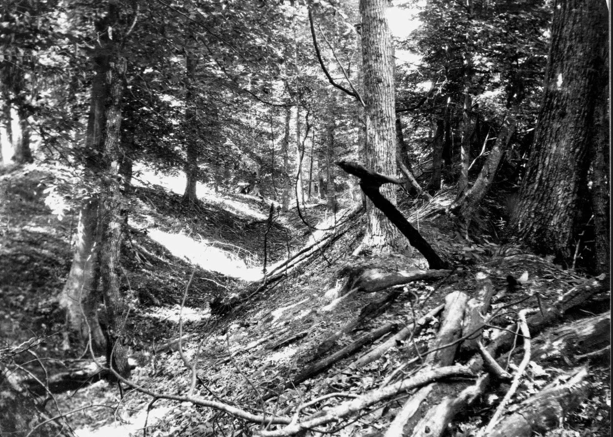
In 1904 scientists documented earthquake-affected landscapes in and near New Madrid, Mo. This photo depicts a landslide trench and ridge in Obion County, Tennessee, about 70 miles southeast of New Madrid. (U.S. Geological Survey)
The 1811-1812 New Madrid Earthquakes were preceded by at least two other similar sequences in about the years A.D. 1,500 and about the year A.D. 900, according to the U.S. Geological Survey.
“It’s not like clockwork but it appears the large earthquakes have occurred in the New Madrid Seismic Zone about every 500 years, and it has been about 200 years since the last ones,” said Thomas Pratt, a U.S. Geological Survey research geophysicist based in Reston, Va.
“So, there is a chance there could be a fairly large earthquake in the NMSZ, and we give it about a 7 to 10 percent chance that there could be an earthquake of that size in around the next 50 years.”
An earthquake of the same magnitude in southeast Missouri likely would not cause extreme damage in the Kansas City area, Pratt said.
“In Kansas City, if you are in a tall building, you probably would feel the building swaying quite noticeably. You might hear something that sounds like a sonic boom. If you are in a house you might see tables shaking, or books falling off shelves.”
More honorable than not
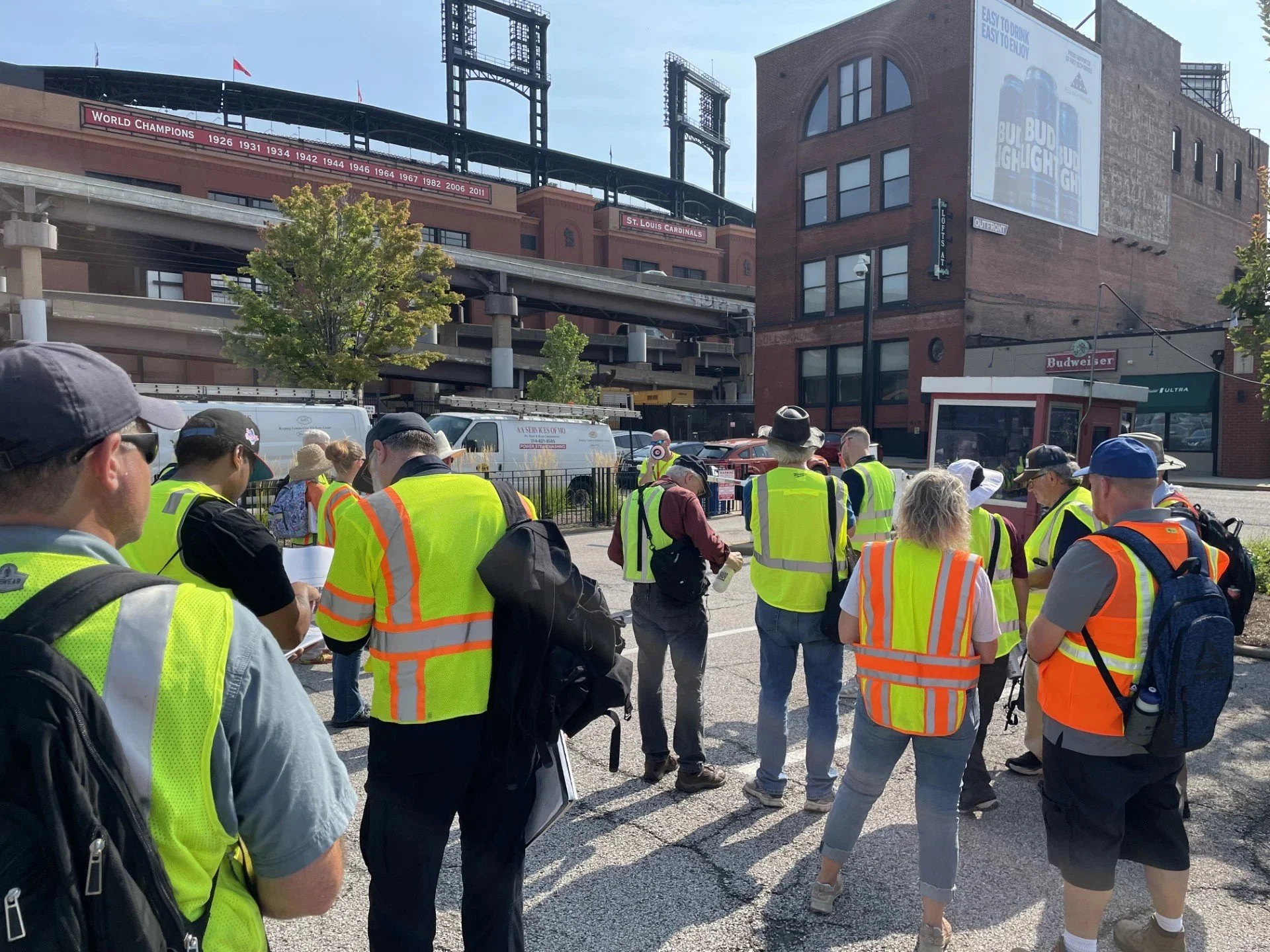
In July, 2024, a 500-member emergency response team took part in a large-scale earthquake preparedness exercise, conducted near Busch Stadium in downtown St. Louis. (Missouri State Emergency Management Agency.)
The organized emergency earthquake preparedness of today is part of the New Madrid earthquakes’ legacy.
The first instance of federal emergency disaster assistance was in response to those events.
So was the first instance of federal disaster relief corruption.
William Clark, who with Meriwether Lewis had embarked on the Mississippi River as they had left St. Louis on their 1804 expedition to explore the Louisiana Purchase, helped persuade the Missouri territorial assembly in 1814 to petition Washington for disaster relief following the New Madrid quakes.
The subsequent New Madrid Relief Act was the first federal response of its kind.
It allowed landowners whose parcels had been damaged to receive a certificate which could be exchanged for between 160 and 640 similar acres in public domain real estate.
The difference between the bargain price the ruined land might be sold for, and the price that the newly-received undamaged land might later attract, could perhaps be pocketed by anyone less than scrupulous.
The relief act, once approved, prompted speculators to rush to the New Madrid area to persuade landowners holding titles to damaged parcels - and who likely had not learned of the federal disaster relief legislation - to sell their properties at everything-must-go prices.
Among these speculators would be Clark himself, who dispatched two agents to purchase some of that ruined land.
All this didn’t happen immediately.
There was the small matter of defeating the British in the War of 1812, which began about four months after the last of the New Madrid earthquakes on February 7.
President James Madison felt that one.
On the same day, writing to former President Thomas Jefferson from what often was called the President’s House in Washington, Madison wrote “…the re-iteration of earthquakes continues…There was one here this morning at 5 or 6 minutes after 4 o ‘C.”
In August 1814, British troops burned the President’s House; neither James or Dolley Madison were home at the time.
The war ended the following February 17, when both England and the United States ratified a peace treaty.
On the same day Congress approved the disaster relief.
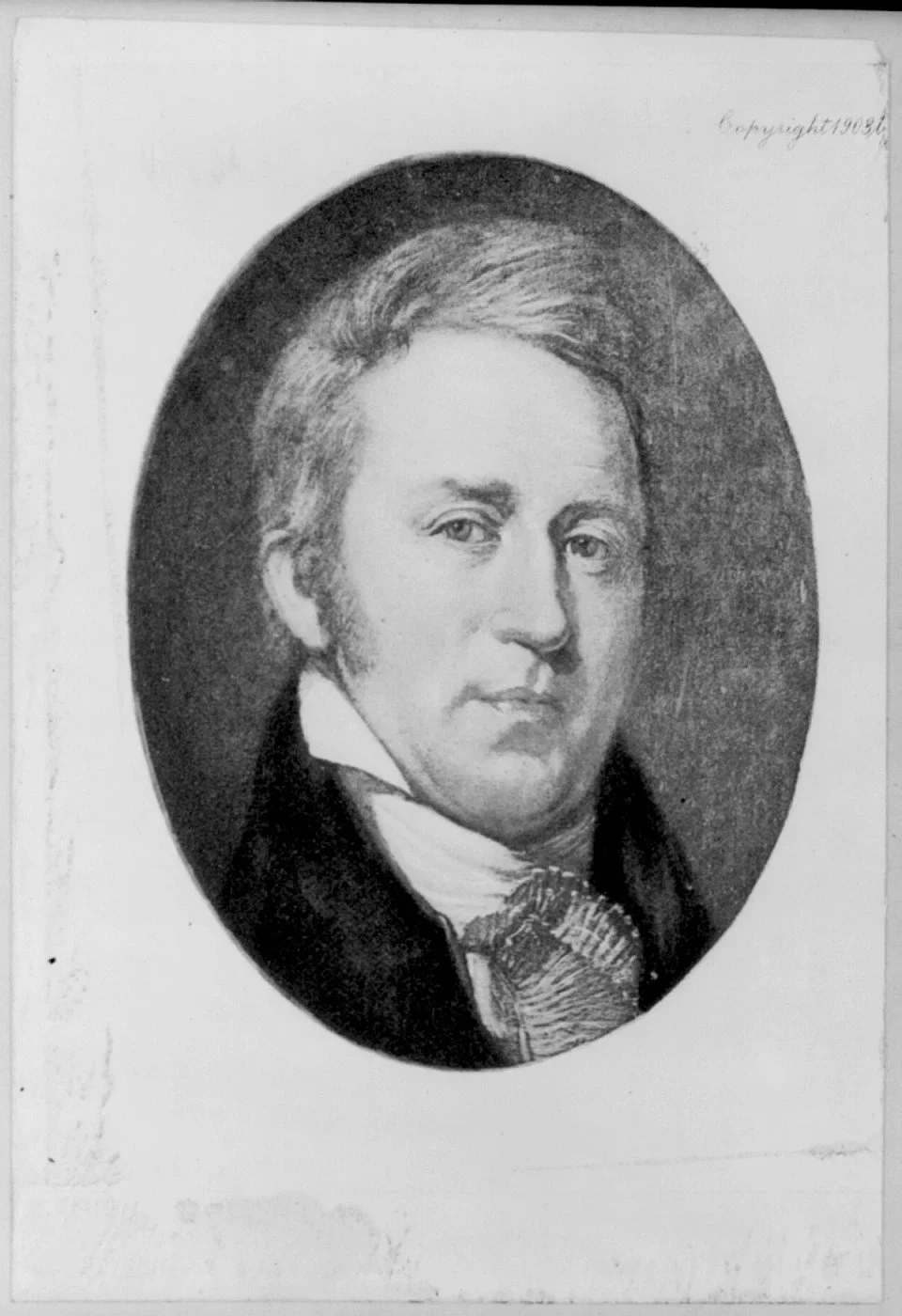
William Clark, Missouri territorial governor from 1813 to 1820, helped the territorial assembly petition Washington for federal government relief following the New Madrid earthquakes. (Library of Congress)
Clark’s subsequent behavior became a political vulnerability in the territory’s factional politics.
“I don’t know the full details of Clark’s actions but his aim was to make a profit,” said William E. Foley, retired history professor emeritus at the University of Central Missouri and the author of “Wilderness Journey: The Life of William Clark,” published in 2004.
“Land speculation was commonplace and he was joining the fray.”
When Clark died in 1838, he held considerable land holdings but not just from his New Madrid real estate speculation, Foley added.
Any such acreage would have represented a small percentage of his personal real estate. Other parcels either had been inherited, awarded by the government for his service on the expedition to the Pacific, or purchased during his lengthy post-expedition career as a Missouri public servant. That included serving as Missouri territorial governor from 1813 through 1820.
“As governor his intent in lobbying for federal relief for his constituents was honorable,” Foley said.
“New Madrid had been devastated; the area was pretty much in ruins. And remember, seeking government disaster relief was not a routine thing at the time. But with his connections he made it happen.
“He was simply doing his duty.”
But Clark, at the same time, Foley said, chose not to pass up a personal business opportunity.
“As this story was unfolding he was looking after a large family and it occurred to him that he could buy up some of these land titles for exchange,” he said. “He was out to make a buck, clearly.
“From his vantage point, he was simply doing business.”

Brian Burnes is a former President of the Jackson County Historical Society.