Our Neighbors

Street scene of the south side of Main Street in Blue Springs, with numerous people and agriculture equipment and horses. Jackson County Historical Society Archives PHL 1997
Blue Springs, Missouri
Founded: 1845
Blue Springs' history is tied to the migration of settlers on their westward journey. Pioneers found the area to be an ideal stopover due to the abundance of cool, clean water from a spring of the Little Blue River - hence the name Blue Springs.

World War I military unit in formation on Hudson Street ca. 1917-1919. Jackson County Historical Society Archives PHM 9067 A-C
Buckner, Missouri
Founded: 1875
Buckner was originally known as Buckner Hill. In its inception Buckner was a railroad depot town for the Missouri Pacific Railroad.

Grain Valley firetruck. Jackson County Historical Society Archives PHL 20897
Grain Valley, Missouri
Founded: July 11, 1884
Grain Valley was the combination of two towns - Pink Hill and Stony Point. It has primarily been a farming community from the 19th century to the 21st century today.

Business buildings in Grandview, Missouri. First National Bank, with an adjoining building. Jackson County Historical Society PHS 26806
Grandview, Missouri
Founded: February 6, 1912
Grandview is where 33rd President Harry Truman grew up working on the family farm. Grandview grew from a farming community into a rail town beginning in 1912, and eventually became home to many servicemen and women stationed at the nearby Richards-Gebaur Air Force Base until its closure in 1994.

View of Main Street in Greenwood, Missouri in the 1920s. Jackson County Historical Society Archives PHL 23121
Greenwood, Missouri
Founded: 1867
Over 140 years ago the name Greenwood was filed for court record on June 25, 1867, by R.W. Price, Frank Brooks, Alfred Hanscomb and the Rev. S.B. Clark. An earlier business district has been located about 1/2 mile northwest of the present school, but this was abandoned for the current site when the railroad came through after the Civil War. In 1870 Lincoln College was founded in Greenwood. By 1900, Greenwood had two train depots that average 100 trains every 24 hours.

Lexington Ave. on the Independence Square, circa 1940.
Independence, Missouri
Founded: 1827
Independence, Missouri was founded in 1827 to serve as the westernmost port of the fur trade on the Missouri River. It later served as a jumping-off point for the Santa Fe, Oregon, and California Trails, and two battles were fought here in the Civil War.
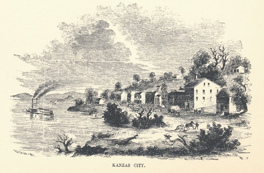
Kansas City, Missouri
Founded: 1853
The origins of Kansas City date to the early 1800s, when French fur traders arrived by the Missouri River and built rough cabins along the river. The Town of Kansas was formed in 1838 and a trail connecting the river landing to the Santa Fe Trail in the town of Westport was established.
Today, several townships have been annexed by Kansas City creating neighborhoods, including Martin City, Waldo, Westport, Hickman Mills, and Knobtown.

Initial filling of Lake Lotawana. Jackson County Historical Society Archives PHL 11711 A
Lake Lotawana, Missouri
Founded: December 30, 1927
Lake Lotawana was conceived, purchased, built and developed by Milton Thompson, owner of nearby Highland Farms, the world's largest Hereford cattle breeding farm at that time. He had previously developed nearby Lake Tapawingo, a lake community with retreats for wealthy Kansas City businessmen.

Progressing stages in development of Lake Tapawingo. Showing lake level on March 1927. Jackson County Historical Society Archives PHL 11712 A-D
Lake Tapawingo, Missouri
Founded: 1926
Lake Tapawingo was constructed by the Lake Tapawingo Development Company in 1926 as an "exclusive sports retreat and rest haven." The City of Lake Tapawingo was officially formed in 1962 in order to prevent annexation by the larger cities of either Blue Springs, Missouri or Independence, Missouri.

Lee’s Summit, Missouri
Founded: October 28, 1865
Originally founded as the Town of Strother in 1865 by William B. Howard, Lee's Summit was named for Dr. Pleasant Lea, the town's physician at that time, who was shot and killed during the Civil War near the present site of the Missouri Pacific Depot. The Summit portion of the name was used since the town's site, (1050 feet above sea level) is the highest point on the railroad between Omaha and St. Louis. When Dr. Lea's name was originally painted on the box car, which served as the town's depot, it was misspelled and was never corrected

Lone Jack Post Office and M.E. Wilson Grocery and Meats with postmistress Maude Wilson, posing with her shepherd dog in front. Jackson County Historical Society Archives PHM 7395
Lone Jack, Missouri
Founded: 1841
Its name comes from a single black jack tree that stood as a local landmark. A post office has been in operation at Lone Jack since 1839. On August 16, 1862, Federal troops were defeated in the Battle of Lone Jack by a much larger Confederate force. The fighting literally occurred on the main street and raged for five hours before the Federals withdrew.

Oak Grove Business District, ca. 1874 Jackson County Historical Society Archives PHL 444
Oak Grove, Missouri
Founded: July 25, 1840
The first post office was opened on July 25, 1840 bearing the name of Oak Grove, however the town was originally called Lickskillet. The town was laid out by William E. Frick. At the time of incorporation there were 11 stores, a school, church, livery stable, mill, post office and hotel. In the early 1900's, Oak Grove held horse shows that drew nearly 10,000 people and 250 entries in 40 categories.

The Rice-Tremonti Home , along with Aunt Sophie's Cabin, has borne witness to more than 170 years of American history. This site was first settled in 1836 by Archibald Rice and family. They built the still standing, Gothic-Revival farmhouse in 1844, a homestead and campsite on the Santa Fe Trail. It served as a jumping off point for emigrants on the Oregon and California trails and is mentioned in many emigrant diaries as a popular campsite and a place where they could purchase food. The trails passed along the north and west side of the home. In addition to the home, several log structures were built on the property in the mid-1800s. The one that still stands, Aunt Sophia White's Cabin, was built in the 1830s. Note: The Rice-Tremonti Home is not associated with the Raytown Historical Society. Jackson County Historical Society Archives PHM 6616 A-C
Raytown, Missouri
Founded: 1849
Raytown was born in 1849 from blacksmith William Ray's hammer and anvil. Raytown began as a Santa Fe Trail stop just eight miles south of Independence, and is probably the second oldest town in Jackson County.

Main Street (Fairmount Ave.) in Sugar Creek in 1908. Street scene in front of post office, with several horse drawn carriages and people. Jackson County Historical Society Archives PHL 14
Sugar Creek, Missouri
Founded: 1904
Land for the Standard Oil Refinery was acquired about 1903 from the James Mallinson farm. It was rumored at the time that the land was being bought up as a goat farm. In fact it was being purchased as the site for the new oil refinery. The refinery began operations in 1904. Employees were brought in from the Standard facility in Whiting, Indiana. Living quarters for workers were tents. Two long sheds of rough wood were used as bunk houses. Mike Onka Sr. came to Sugar Creek in April 1904 from Whiting and a month later his wife joined him. The Onkas recalled that there were only three or four houses in Sugar Creek when they arrived. They belonged to Bill Mallinson, Fred Dickey, E.K. Anderson and Col. N.P. Simonds. The townsite of Sugar Creek was platted and sold for home sites that year. Residential construction started in earnest. A four-room brick school was erected in 1905 after a bond issue of $33,000 was passed by a unanimous vote of 47. The Sugar Creek refinery closed in 1982. Sugar Creek is known for its large population of slavic immigrants.
Villages in Jackson County

Train station in Atherton, Missouri. Jackson County Historical Society Archives, PHL 500
Atherton
Founded: 1888
A post office called Atherton was established in 1888, and remained in operation until 1976. The community was named after a railroad employee. During WWII, German prisoners of war worked on farm land and assisted in loading trains with produce.

Photos of high water in Levasy, October 1973. Jackson County Historical Society Archives PHM 19854 A-F
Levasy, Missouri
Founded: 1877
A post office called Levasy has been in operation since 1877. The city was named after William Wallace Livesay, an early settler

Engraving shows the river bend at Kansas City. Boats are on the river, horses & carriages on the shore, Kansas City buildings are in the background. Jackson County Historical Society Archives PHL 5299.
River Bend, Missouri
Founded: 1951
It is the only part of Jackson County that lies north of the Missouri River. In 1949, the Missouri River was relocated to a new channel, creating River Bend in 1951, (also known as Liberty Bend). The county line still follows the original riverbed. In 2010 the population was 10.

End view of frame two-story train station with Santa Fe logo and "Sibley" painted on end of building. Jackson County Historical Society Archives PHM 1152
Sibley, Missouri
Founded: 1836
Archibald Gamble officially platted the Town of Sibley in 1836. Gamble, the brother-in-law of the Fort Osage factor George Sibley, named the town after Sibley. Using the Fort Osage landing and planning on ferry operations, Gamble and Sibley envisioned a town made prosperous from river trade, steamboat outfitting, and providing goods and service for overland trail travelers. The town did experience a modest amount of prosperity in the late 1830s and early 1840s. Sibley suffered from a series of tragic events. In 1844, a severe flood destroyed many of the businesses located at the base of the bluff. The town was also virtually destroyed by Union forces in June 1863, as Sibley was a refuge for Confederate guerillas during the Civil War. A serious fire in 1878 and a tornado in 1880 again damaged much of the town. In 1887, the Santa Fe railroad crossed the Missouri River at Sibley, and the business center and most of the residents moved about a half-mile to the south around the railroad depot. It is known as the home of Fort Osage National Historic Landmark.

View of buildings with tower in background at Unity Village, Missouri. Jackson County Historical Society Archives PHL 596
Unity Village, Missouri
Founded: 1919
Charles Fillmore purchased 1,200 acres farm land to develop the village of Unity Village, now the present day location of Unity Worldwide Headquarters, a religious organization. The landmark Unity Tower was designed by the Kansas City firm Boillot & Lauck and built in 1929 to store water. Unity Village is the location of the largest water fountain in Jackson County.
The Lost Towns
Blue Mill
Founded: 1835
The community was named for a watermill on the Blue River. A post office called Blue Mill was established in 1835, and remained in operation until 1895. A variant name for the town was Twyman.
Cockrell
Founded: 1886
The town was named after Francis Cockrell, a state legislator. The town dissolved in 1902. A mercantile store is still operated here.
Courtney
Founded: 1888
The town was named after C.C. Courtney, an early settler. The town dissolved in 1962.
Hickman’s Mill
Founded: 1854
Named for Edwin Alfred Hickman who purchased land to build a steam-powered grist and saw mill along Hart Grove Creek. He had moved down from Independence when wood became scarce for his mill there and he sought to take advantage of the large amount of traffic on the nearby Santa Fe Trail at that time. Its current given name is due to a clerical error in the second half of the 19th century; when the community around Hickman's Mill applied for a federal post office, the officer in Washington, D.C., mangled the name to "Hickman Mills
Marboulgh
Hick’s City
Founded: 1872
A post office called Hick’s City was established in 1872, and remained in operation until 1906. The community was named after Russell Hicks, the original owner of the site.
Hiler
Founded: 1893
A post office called Hiler was established in 1893, and remained in operation until 1902. It is located to the north of Pink Hill on Buckner Tarsney Rd before Buckner.
Pink Hill
Founded: 1854
A post office called Pink Hill was established in 1854, and remained in operation until 1902. It is located on Pink Hill Road roughly between South Howell Road and South Fields Road. The community was named for a hill near the town site where pink flowers grew.
Sni Mills
Founded: 1871
A post office was established at Sni Mills in 1871, and remained in operation until 1902. The community was named after nearby Sni-A-Bar Creek.
Tarsney
Founded: 1891
A post office called Tarsney was established in 1891, and remained in operation until 1902.